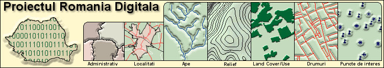
The Digital Romania Project: timeline
1. Everyone who will take part in the Digital Romania Project will receive at least a CD with the final result, a CD that can be watched on the PC and whose data can be loaded in the Garmin GPSes that can display MapSource compatible maps.
2. According to the quantity and the volume of the delivered data, the participants will benefit from major discounts at the purchase of any Garmin navigation or sonorous systems, discounts that will be discussed from one case to the other.
3. All the participants will be given credit for the provided data and are allowed to make a HTML presentation page on the CD, of maximum 1 MB, that will show their capabilities, accomplishments, knowledge, their experience and the geographical area where they activate. This page will also have to contain a bit man with the sequence of the map provided by the author to this project.
4. All participants are still sole possessors of the copyrights on all the data transmitted in the Digital Romania Project, and they give us the right to include THEIR data in OUR product for a period of 5 years, in exchange of the advantages from 1, 2 and 3.
5. The form under which the geographic data will be published is a closed one, so that no one will be able to pirate the product and to use the geographic data without the agreement of the copyright holders.
6. Garmin is a de facto leader on the international market of GPS navigation systems. The map drawn up during the Digital Romania Project will be globally accessed and the credit of those who took part in the project will be very significant.
7. We’ll also draw up theme maps containing data of a more restricted nature for your customers that can be easily uploaded on your Garmin GPS.
8. The Digital Romania Project is unique on the Romanian GIS market and its aim is to create the premises of the collaboration and cooperation among specialists, creators and map users in Romania. The Romanian Athenaeum was built as a result of the media campaign "Give a Leu for the Athenaeum" and, with little form everyone, something spectacular resulted.
9. Any geographic data of much interest, bitmap or vector, is important for this map. If you have something, but you are not sure whether it is interesting or not, you’d better ask us...the list of those willing to be part of this project will be constantly brought up -to- date on the project’s website, and, apart from the names of the participants, it will also state the areas they cover and the theme layers, so that a superposition to be avoided.
10. The checking of the data will fall on us and we reserve the right to decline data that is incorrect, false or has many errors. Thus, being one of the accepted people is a proof of professionalism, seriousness, and, least but not last, patriotism....