Digital Romania Project: local distributors
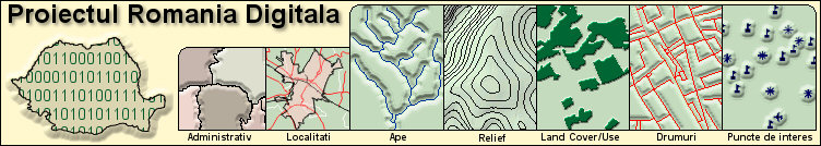
For the first version of the Digital Romania Atlas, the reference scale will be of 1: 15 000 for the city areas and 1: 100 000 for the rest of the country. The included space information (thematic layers) in the Digital Romania Atlas will be structured as follows:
A. Types of points
1. Political entities
- centres countries/counties/towns, different sizes
2. Business – Food and drinks (Points of interest that can be searched)
- restaurants (different specialties and kitchens), fast food, cafés, pizzas
3. Business – Accommodation (Points of Interests that can be Searched)
- motel accommodation and breakfast, tents, hotels, tourist resorts
4. Business – Tourist Attractions (Points of Interests that can be Searched)
- arenas, parks, gardens, libraries, schools, museums, etc.
5. Business – Entertainment (Points of Interests that can be Searched)
- bars, bowling, casino, arena, golf course, theatre, cinema, ski, etc
6. Business – Purchases (Points of Interests that can be Searched)
- shop, supermarket, pharmacy, mall, etc
7. Business – Services (Points of Interests that can be Searched)
- airport, service, gas stations, ACR, bus, trolleybus, tram, maxi taxi, underground station, parking, floating dock, post offices, etc.
8. Business – Emergencies and Government (Points of Interests that can be Searched)
- custom, municipality, court, hospital, police station, etc.
9. Name of geographic points of Interest made by humans
- bridge, building, cemetery, church, phantom historical town (archeological site/caster/fortress), earth berm, mine, choker-hall, well, etc.
10. Name of Geographic Points of Interest related to Water
- bay, navigable channel/irrigations, lake, river, port, island, glacier, geyser, torrent, spring, sea, swamp, cascade, etc.
11. Name of the geographic points of interest related to the Earth
- peak, crater, plateau, forest, isthmus , rockery, field, reservoir, valley, peak, forested area, etc.
12. Different point of interest
- company, bell, landing stage, barrage, dangerous area, drinkable water, fishing place, house, information, controlled area, showers, shelter, public phone, kilometric born/point of topographic support network, point with known depth, point with known height, wreck, scenic area, etc.
B. Types of lines
1. Roads
- European, national, regional, village, forestry roads, streets, alleys, paths, etc.
2.
- rivers, brooks, mountains streams, etc
3. Politics
- regional, state, county frontiers
4. Outlines
- elevations and depth
5. Different lines
- runaways, ferryboat line, petroleum/water pipes, high voltage lines/telecommunications, railway, border line, path to be crossed by foot
C. Types of surfaces
1. Urban Areas
- different sizes towns
2. Different large structures made by humans
- Ports, Hospitals, Commercial Areas, Military Basis, Gulf land, Universities, Miscellaneous, Industrial, Airports, etc.
3. Parks
- urban, county and national parks
4. Waters
- seas, lakes and rivers of various sizes
5. Covered surfaces
- sands, glaciers, forests, bushes, orchards, vineyards, swamps, etc.
Final Sale Price of the CD: 166 EUR +VAT