| |
|
|
|
Global Mapper more than a visualizing instrument, able to display the most usual sets of raster data, elevation or vector. It converts, edits, prints, creates GPS tracks and will allow you to use GIS functions of your data sets, under a software package with an incredible low price and easily to use. The new version 7.xx offers you the possibility of direct accessing the whole TerraServer data base, that contains USGS satellite images and topographic maps and visualizing elevation data in 3D format!
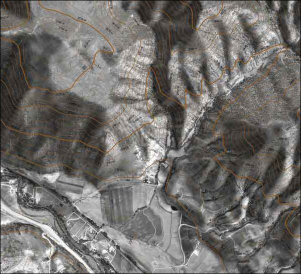
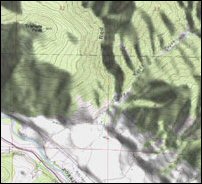
 Your data folders can be loaded as layers, for example a Digital Elevation Model can be loaded together with a topographic map, scanned in order to create a 3D representation with lights and shadows of the map. An air digital image can be represented together with a vector map of contours in order to create a spectacular graphic. The results can be printed or exported as raster images of high resolution in order to be used in presentations and reports.
 Have you ever received a data set that does not fit, from the point of view of the projection, to your current project? All you have to do is to load the data set in Global Mapper, to change the projection and to save the folder so that it is represented in the same coordinate system. If the data set is bigger than the surface you are interested in, you can export the data using Crop option and you can change the projection and the data format in the same time.
 Global Mapper is more than a simple utility program; it has incorporated functions for calculating the distances and surfaces, combinations of bitmap images and contrast adjustments, elevation analysis and calculations of line of sight, and advanced functions like image rectifications, contour set up, view shed on the base of surface data, and triangulations and gridding for 3D data. There can be repetitive processes using the incorporated scripts of the numerous conversion options on portions.
|
|
Short description of the Global Mapper facilities
- Supports the view of the most popular data formats, including DLG-O, DRG, DOQ, DEM, DGN, DXF, SDTS DLG, SDTS DEM, ECW, MrSID, ESRI Shapefiles, E00, MapInfo MIF/MID, MapInfo TAB/MAP, GTOPO30, TerrainBase, SRTM, ETOPO2, ENVI DEM, JPG, PNG, BIL, BSQ, BIP, XYZ, Tiger/Line, Arc Vector Coverages, VPF (VMAP, DNC), S-57, CADRG, CIB, JPEG2000, GIF, NOS/GEO, Garmin PCX5, OziExplorer WPT/PLT, Zmap Plus Grids, etc.
- Offers direct access to the whole archive of satellite images and topographic maps TerraServer for free, without requiring quitting the application.
- Supports the 3D view of the loaded elevation data, including the superposition of any image over a tridimension surface.
- Supports the newest formats DEM and SDTS DEM, including decimeter DEMs
- Detaches, reprojects and joints any bitmap data combination, including DRG.
- SUPPORT FOR DIGITALIZATION! You may digitize new vectorial elements (surfaces, lines and points) by drawing them with the help of the mouse. Likewise, you may edit the existing vectorial elements. The newly created elements and the edited ones can be saved in any of the supported export formats.
- SUPPORT FOR GPS! It allows superposing in real time the track of a GPS connected to the computer serial port, over any loaded image. Besides, it allows marking waypoints and saving itineraries.
- SUPPORT FOR EXPORT! You may export both vectorial data and bitmap or elevation data in a wide variety of formats (see below). You may unify any combinations of data sets, whichever might be the scale, the type or the protection of the source data. Below, you will find the list of the formats under which you may export the data.
- Vector data (ex. DLG, Shapefile, DXF, etc.)
- Format AutoCAD DXF
- Format CDF
- Format ESRI Shapefile
- Format Garmin PCX5 TRK si WPT
- Format Generic ASCII Text
- Format InRoads ASCII
- Format Landmark Graphics
- Format MapGen
- Format MapInfo MIF/MID
- Format MatLab
- Format NIMA ASC
- Format PLS CADD XYZ Grid
- Format Surfer BLN
- Format SVG (Scalable Vector Graphic)
- Format Tsunami OVR
- Format USGS DLG-O
- Raster data (Bitmap) (ex. DRG, DOQ, etc.)
- Format BIL/BIP/BSQ
- Format ECW
- Format GeoTIFF
- Format JPG
- Elevation data (ex. DEM, etc.)
- Format USGS DEM
- Format BIL
- Format GeoTIFF DEM
- Format Surfer Grid (ASCII si binar)
- Formate DXF (3D-point, 3D-mesh si 3D-face)
- Format XYZ ASCII Grid
- Format Arc ASCII Grid
- Format PLS CADD XYZ Grid
- Format Float/Grid
- Format RockWorks Grid
- Format STL
- Format Terragen Terrain
- Format VRML
- Format MapMaker Terrain
- Format Zmap Plus Grid
- Format Leveller Heightfield
- IMAGES CORRECTION! You may rectify graphically (geo-reference) any JPG, TIFF or PNG image and you may save the result as a new image, completely geo-referenced.
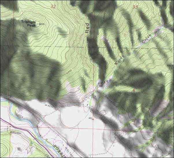
- BORDERS ENGENDERING! You may create borders for any combination of elevation data. You also may specify the interval between the borders you want to use. The engendered border data may be then exported in any supported vectorial format (see the list above).
- Triangulation and automatic gridding for 3D data. This allows you converting a set of elevation samples in a set of grid data that may be subsequently used for the borders engendering, line of sight analysis and coverage analysis (view shed), among others. The data also may be exported in any of the supported elevation grid formats, as, for instance USGS DEM.
- The advanced grid capture. You may capture the image on the screen under as a BMP, JPG, PNG or (Geo) TIFF file, with the specified resolution.
- The conversion by portions of any type of entry data file.
- Automatic removal of the white borders for DRGs. This allows you perfectly viewing a collection of adjacent files of the type DRG.
- Supports opening the SDTS DLG and SDTS DEM files directly from the archives .tar.gz. and .zip. This way you avoid the problems occurring at the dearchiving each transfer SDTS in separate directories.
- Perfect coverage analysis by using the grid elevation data from a location, a height of the transmitter and a specified operating range.
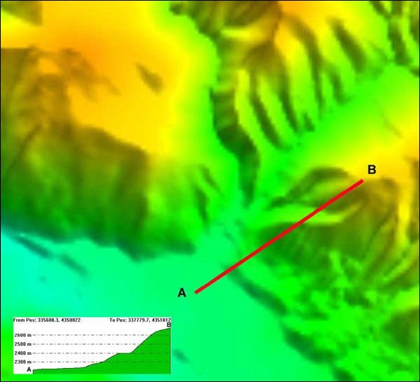
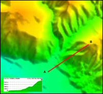
- The 3D profile of the itinerary and applications Line of Sight (LOS), including the height of the transmitter/receiver, minimum visibility and bend degree of the Earth.
- Supports opening the DLG-O and DEM files directly from the gzip archives. This means you may save time and space on the hard disk, without being necessary dearchiving the data after download.
- Display of the descriptive text. When you move your cursor on the screen, you will obtain in the status bar the description of each element situated in the neighborhood of the .S cursor
- Supports the navigation by the keyboard. You may move the map with the arrays and use the Zoom function by the keys page up and page down.
- Supports searching by name for all the loaded vectorial data.
- And more than that!
|
|
|