| |
|
|
|
Whether you are a specialist in geography, topographic surveying, cadastre, geology, natural resources, whether you just love/ practice alpinism, horse-riding, camping, hunting, biking, motoring, fishing, hiking or a little bit of each - SHEBA DISTRIBUTION, as unique representative of Garmin in Romania, offers a very wide range of products, suitable for your activity. You will discover in our product range a device that will most certainly fit to your needs and to your budget.
|
|
|
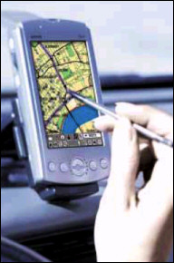
Garmin GPS portable terminals are products of American high-technology that will help establishing your current position, the covered distance and the speed rate. The device, in the dimensions of a mobile phone, incorporates the following standard facilities:
- reception of 12 NAVSTAR satellites (parallel)
- high-precision determination of the geographical coordinates (latitude/longitude, UTM/UPS, STEREO 70, etc.), the direction to a specific location, current altitude, speed and time of the motion, total covered distance)
- the map of the distance covered, with possibility of inserting minimum 500 points of track (waypoints)
- planning at least 10 ways, with over 30 symbols for each
- GO TO option, with displaying the speed rate, the distance and the time left until reaching the destination etc.
- RS232 interface with NMEA 0183 and RTCM 104, differential corrections DGPS or WAAS/EGNOS
- cover endowed with ultrasonic, water resistance according to IPX7 standard
|
|
 |
|
|
|
|
Supplementary options, depending on the chosen model: receiver of WAAS/EGNOS differential corrections, incorporated map, data base of cities or points of interest, external antenna, added memory, barometric altimeter, electronic compass, mounting adapters on board or on the vehicle windshield, fixing system on the bike/motorcycle handle bar protection covers, PC connection cables- USB or RS232.
|
|
 |
|
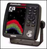
Garmin Sonars (with or without incorporated GPS) offers the simplest professional solutions for:
- fish locations, displaying the depth at which they are located and their sizes
- ringing alarms at fish appearance, warning shallow or deep water
- graphic representation of the bottom of the water (relief, consistency, depth)
- underwater vegetation
- water temperature
- speed rate of the ship.
|
|
|
|
|
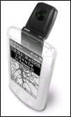
Garmin OEM Sensors represent the first GPS modules that offer superior performances and flexibility, each being thought to ensure the client the right choice for the implementation of any GPS application. Each sensor sets NMEA data exit, DGPS capabilities or WAAS/EGNOS, non-volatile memory for configuration, clock of real time and data exit for the most sophisticated applications of the client.
The new CompactFlash cf Que™ 1620 module will transform the laptop or the PDA (PocketPC platform) in an excellent and complete navigation tool, and you will take advantage of maps detailed at street level, vocal indications turn-by-turn guiding, automatic search of addresses, points and ways marking, route calculation and re-calculation, etc.
|
|
 |
|
|
|
Consulting our reference list, you will be surprised to find out that in Romania too, Garmin is the solution that the mates in your field prefer and you will discover, contacting our clients, old and new applications, which you can add to those specific to your activity. We are convinced that, after the latest regulations, marking and subsequent finding of points in geographical coordinates is a field of interest for your activity.
Our website, www.rqa.ro contains all the technical information that you will need in order to perform compared analyses between the capabilities of different models in our products range.
Garmin equipments are a reference solution in the world, concerning the purchase and the integration of position information with modern GIS systems, both by attractive price and performances, use easiness and integration of communications interfaces with the computer, of the extended memories, of the barometric altimeters and of the electronic compasses
Contacting us by phone/fax 021/413.02.54, 413.79.21, 726.35.13 or sending an email at sales@rqa.ro, our professional personnel will be glad to supply the commercial and technical information you need in order to consolidate your opinion.
|
|
|
|
|