RO.A.D.2016.32 Launch
Sheba Distribution SRL, a Garmin representative in Romania, has the pleasure to announce the availability of the new edition of the Digital Atlas of Romania v8.32, RO.A.D.2016.32.
Continuing in the well known tradition for the Romanian Garmin customers, the Digital Atlas of Romania holds on to the number one place in the GPS road navigation map charts by bringing an extra 7,132.17 km of roads up to a grand total of 389,742.41 km, having significant increased coverage added in the counties Argeş, Teleorman, Olt, Gorj, Harghita, Vrancea, Hunedoara, Mehedinţi and Caraş-Severin and the number of POIs raises in this edition to a staggering 794,856 points divided into 516 categories.
RO.A.D.2016.32 is the only GPS navigation map in the world that combines topographic details with a routable road network – including dirt roads and trails – with postal addresses of unequaled precision, towns with extruded 3D blocks of flats and detailed 3D textured models for both old patrimony buildings and new skyscrapers, true landmarks of today’s urban space. Map updates are constant and consistent from one edition to another and are documented in the Map Diaries, where all the contributions and their respective authors are mentioned together with the names of the cities and the map tiles that have changed.
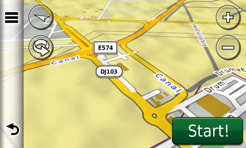
Compared with common maps on the market, the Digital Atlas of Romania has an unequaled level of detail and actuality, featuring the ability to route on the Cunţa-Sălişte segment of the A1 („the demolished motorway”) which was rebuilt in the meantime, the ability to route on the South Ring of Craiova – the so called „Ford Ring” – also opened again for public access, the A1 Traian Vuia-Margina motorway segment de pe autostrada A1 and the Margina, Grind and Ilia bypasses, the DJ107 deviation at the border between Alba Iulia and Ciugud, the E81 deviation from Decea, the Ciheiului overpass from Oradea, the Braşov Ring – the Eastern part, the DN11 overpass, the Sânpetru overpass – without ability to route over, the service areas at Nădlac Customs, the A3 motorway bypass from Moara Vlăsiei, the A3 motorway segment between DNCB and the Popasului bypass as well as the final version of the Bucharest ring 2+2 between Chitila and Dumbrăveni and Chiajna and A1 motorway.
The solar farm and electric utility from Sebeş, the solar farm from Ovidiu, the wind turbines from Casimcea and Topleţ, the solar farm from Tălmaciu, the four photovoltaic parks from Lechinţa, the photovoltaic parks Mănăştiur and Chişcani have been mapped, together with access to them.
In this edition we have postal addresses added in the following towns: CORABIA, TURNU MĂGURELE, BĂDULEASA, CÂRLOMANU, PUTINEIU, BĂNEASA, SALCIA, TUDOR VLADIMIRESCU, VLĂŞCUŢA, STOLNICI, IZBĂŞEŞTI, COCHINEŞTI, PĂDUREŢI, CĂTANE, CIEŞTI, FÂLFANI, COTMEANA (STOLNICI), LUNCA CORBULUI, MĂRŢEŞTI, POPEŞTI (SĂPATA), TURCEŞTI, BĂNĂREŞTI, SĂPATA, BUMBUENI, SILIŞTENI, CERBU, MAREŞ, LĂNGEŞTI, COSTEŞTI, SMEI, PODU BROŞTENI, Broşteni (COSTEŞTI), LĂCENI, STÂRCI, PÂRVU ROŞU, CÂMPU LUI NEAG, Valea de Brazi, PLEŞA, BUMBEŞTI-JIU, ROMANEŞTI, DRĂGOENI, PREAJBA MARE, CURŢIŞOARA, TETILA, LĂZĂREŞTI, IEZURENI, SLOBOZIA, BÂRSEŞTI, Polata, URSAŢI, MERI, LAINICI, TÂRGU JIU, MIERCUREA CIUC, HOSASĂU, VLĂHIŢA, HARGHITA-BĂI, CIBA, MÂNDREŞTI-MUNTENI, MÂNDREŞTI-MOLDOVA, UNIREA, ODOBEŞTI, CĂLIMĂNEŞTI, PĂDURENI (MĂRĂŞEŞTI), HARET, MODRUZENI, SATU NOU, CRUCEA DE JOS, PANCIU, CRUCEA DE SUS, NEICU, TECUCI, SIRETU, MĂRĂŞEŞTI, FOCŞANI, ŞVINIŢA, DUBOVA, EIBENTHAL, BAIA NOUĂ, BERZASCA, LIUBCOVA, COSTENI, CELEI, ISVARNA, POCRUIA, TISMANA, VÂNĂTA, GORNOVIŢA, TOPEŞTI, VÂLCELE, SOHODOL, BREBINA, TITERLEŞTI, BRATILOVU, MĂRĂŞEŞTI, STĂNEŞTI, BÂRÂIACU, OBÂRŞIA-CLOŞANI, ORŞOVA, PECINIŞCA, BĂILE HERCULANE, EŞELNIŢA, POJEJENA, RADIMNA, SUSCA, BELOBRESCA, DIVICI, Baziaş, SOCOL, CÂMPIA, PÂRNEAURA, ZLATIŢA, BERLIŞTE, RUSOVA VECHE, RUSOVA NOUĂ, MĂCEŞTI, SFÂNTA ELENA, LIBORAJDEA, GORNEA, SICHEVIŢA, NICOLINŢ, LEŞCOVIŢA, NAIDĂŞ, MARTINOVĂŢ, STRENEAC, ZĂNOU, CRACU ALMĂJ, VALEA RAVENSCA, VALEA SICHEVIŢEI, CURMĂTURA, CÂRŞIE, FRĂSINIŞ, GÂRNIC, PADINA MATEI, LUCACEVĂŢ, CÂRŞA ROŞIE, VALEA RĂCHITEI, RAVENSCA, OGAŞU PODULUI, BRESTELNIC, CAMENIŢA, CRUŞOVIŢA, PETRILOVA, SLATINA-NERA, BOGODINŢ, SASCA ROMÂNĂ, POTOC, SOCOLARI, Ciuchici, ILIDIA, URCU, VALEA ROŞIE, MILCOVENI, IAM, CIORTEA, VRANI, VRĂNIUŢ, IERTOF, BRATOVA, VALEA MINIŞULUI, PONEASCA, CICLOVA MONTANĂ, ORAVIŢA, BROŞTENI, RĂCHITOVA, BRĂDIŞORU DE JOS, AGADICI, ŞTEIERDORF, ANINA, CUPTOARE (REŞITA), SECU, DOMAN, ŢEROVA, REŞIŢA şi BĂDEŞTI (BÂRLA).
Detailed acces to the retail stores: Takko, Deichman, Penny Market and Kaufland from Alexandria, Lidl Oradea, Lidl and Penny Market from Focşani, Lidl Hărmanului and Lidl Zizinului from Braşov, Lidl and Annabella from Râmnicu Vâlcea, Kaufland, Selgros and Lidl Târgu Mureş, Lidl and Penny Market Paşcani, Lidl and Kaufland Curtea de Argeş, Veranda Mall, Lidl Găzarului and Lidl Liviu Rebreanu from Bucureşti as well as Mega Image Chiajna. New oneway streets and speed restrictions have been added together with 39 (thirtynine) new roundabouts.
We also continued mapping the aristocratic mansions representing historical monuments from Transylvania, as well as orthodox monasteries from all over the country.
The railways junctions from Piteşti, Goleşti (Ştefăneşti), fostul Arpechim, Bradu, Costeşti, Medgidia, Murfatlar, Poarta Albă, Castelu, Dragalina, triajul Palas, Feteşti, Dorneşti, Vicşani, Gura Motrului, Stamora Germană, Sânpetru, Râureni, Râmnicu Vâlcea, Bujoreni, Jimbolia, Bod, Petroşani, Salva, Craiova, Caransebeş, Dărmăneşti and Curtea de Argeş have also been introduced.
History aficionados will discover in this edition in premiere the detailed elements of the possible earth roman castellum from Cobadin, the double ditched roman? castrum? from Topraisar, the roman? castrum? from Pietreni, the probable layout of the aqueduct and the roman? castrum? from Negureni, the roman? legion castrum? and burgus? from Alexandru Odobescu-La Furcituri, the roman? castrum? from Căscioarele, the roman? castrum? from Rupea Gară- La Hill, the roman Burgus from Salva-Cetăţia, the roman watch tower from Salva-Roata lui Todoran, the roman watch tower from Salva-Dealul Belii and the roman watch tower from Salva-Dumbravă, the detailed elements of the early mediaeval Bulgarian fortified settlement Onglos? from Vlădeni-Popina Blogodeasa, the mediaeval? fortifications from Negureni, the world war two trenches from Deleni and Haţeg (CT), the previously unknown world war two anti tank ditch from Southern Dobrudja from Haţeg-Abrud-Deleni-Cobadin-Ciobăniţa-Osmancea-Topraisar-Biruinţa and many more world war two casemates from the territories of the Limanu and Tuzla communes, tens of monuments from the first and second world wars and military cemeteries, most worthy to mention being the ensemble „The Way of the Cross-the Calvary of the Romanian Army in the First World War” from the Cerbu Monastery.
Featuring an original concept, with updates three times a year, the result of 13 years of continuous development of the experts and contributors of the Digital Romania Project team, the Digital Atlas of Romania is the choice of professionals in all fields and the preferred navigation tool for all nature goers.
This edition has 1.00 GB in size and runs exclusively on Garmin navigation equipment, an updated list of compatibility being available at the below link:
http://www.rqa.ro/produs.php?id=442&subcat_id=39&cat_id=19
Warning!
The use of RO.A.D.2016.32 map can create addiction to quality, value, functionality and beauty!
-
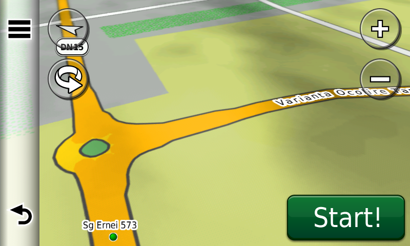
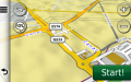
- Giratoriu Ernei VO Targu Mures in RO.A.D.2016.32 pe Nuvi 3790
-

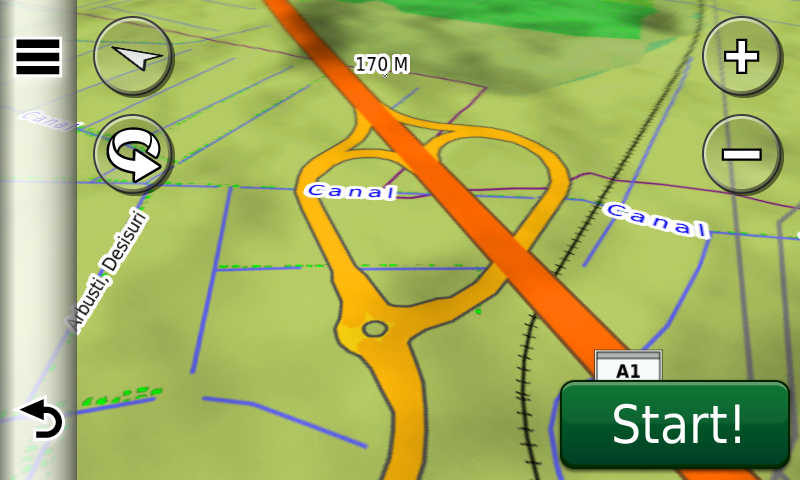
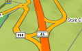
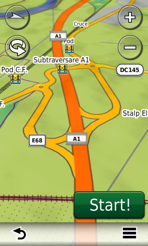
- Nodul Grind pe A1 in RO.A.D.2016.32 pe Nuvi 3790
-
- Nodul Ilia pe A1 in RO.A.D.2016.32 pe Nuvi 3790
-
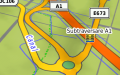
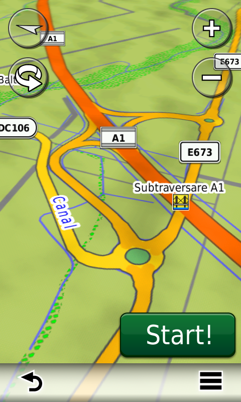
- Nodul Margina pe A1 in RO.A.D.2016.32 pe Nuvi 3790
-

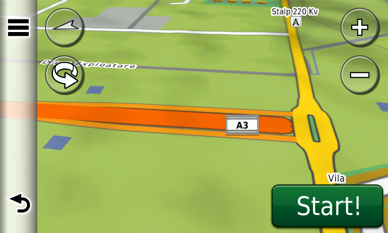
- Nodul Moara Vlasiei pe A3 in RO.A.D.2016.32 pe Nuvi 3790

-

- Nodul Popasului (Voluntari) pe A3 in RO.A.D.2016.32 pe Nuvi 3790
-

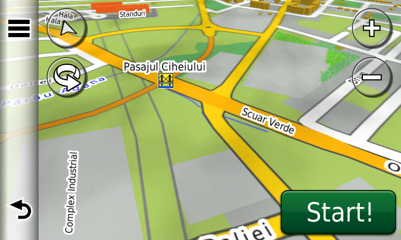
- Pasajul Cihei din Oradea in RO.A.D.2016.32 pe Nuvi 3790
-
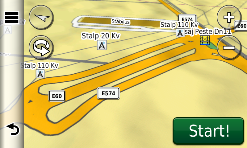
- Pasajul peste DN11 VODN1K Brasov in RO.A.D.2016.32 pe Nuvi 3790
-
- Pasajul Sanpetru peste VODN1K Centura Brasov in RO.A.D.2016.32 pe Nuvi 3790
-
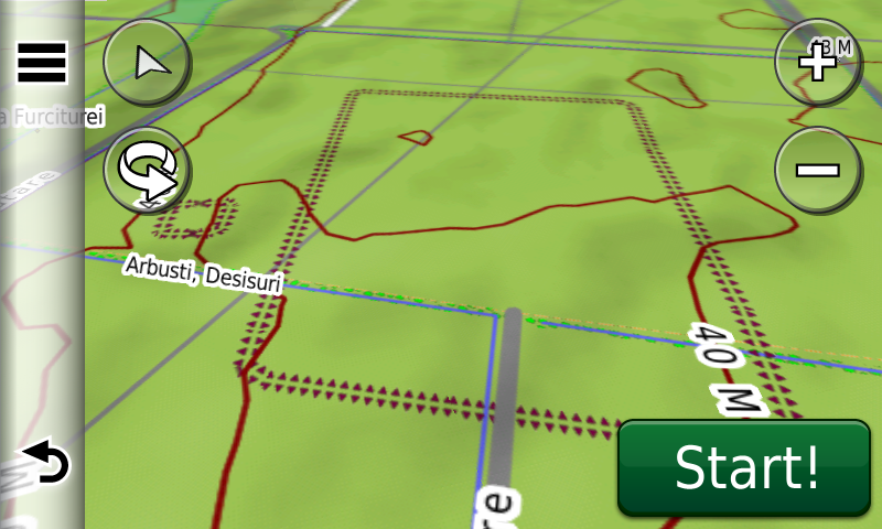
- posibil burgus si castru roman de legiune la Alexandru Odobescu-Furcituri in RO.A.D.2016.32 pe Nuvi 3790-