RO.A.D.2017.13 Launch
Sheba Distribution SRL, a Garmin equipment importer in Romania, has the pleasure to announce the availability of the new edition of the Digital Atlas of Romania v9.13, RO.A.D.2017.13.
Continuing in the well known tradition for the Romanian Garmin customers, the Digital Atlas of Romania holds on to the number one place in the GPS road navigation map charts by bringing an extra 9,722.60 km of roads up to a grand total of 399,465.01 km, having significant increased coverage added in the counties of Argeş, Olt, Gorj, Vâlcea, Hunedoara, Alba, Sibiu and Caraş-Severin and the number of POIs raises in this edition to a staggering 825,237 points divided into 519 categories.
RO.A.D.2017.13 is the only GPS navigation map in the world that combines topographic details with a routable road network – including dirt roads and trails – with postal addresses of unequaled precision, towns with extruded 3D blocks of flats and detailed 3D textured models for both old patrimony buildings and new skyscrapers, true landmarks of today’s urban space. Map updates are constant and consistent from one edition to another and are documented in the Map Diaries, where all the contributions and their respective authors are mentioned together with the names of the cities and the map tiles that have changed.
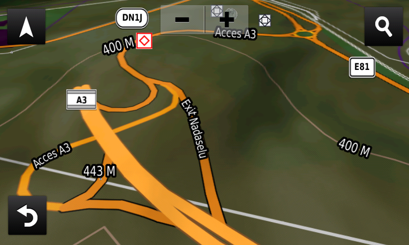
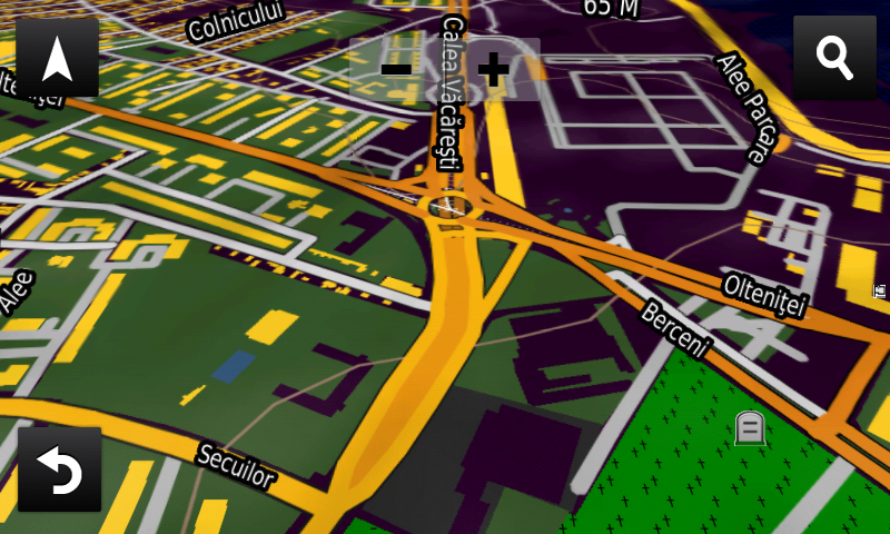
Compared with common maps on the market, the Digital Atlas of Romania has an unequaled level of detail and actuality, featuring the ability to route on the underground Piaţa Sudului Passage from Bucureşti (opened for traffic today!), the new configuration of DC97 west of Baia Mare airport, the new routing solution at Otopeni Passage over DNCB, the service spaces from DN1K Braşov, the south ring of Ineu, the Ploieşti-Vest Passage, the new DJ142J between Şeica Mică and Şeica Mare, the capability to route over the Sânpetru Passage, the E81 deviation from Lancrăm, the DN14B deviation from Crăciunelu de Jos as well as the A3 Nădăşelu Bypass (without routing).
The solar farm from Măgurele, Gălbiori, Carei, Cristuru Secuiesc, Berceni and Ploieşti, the oilfields from Oarja and Ţicleni, the energy generators from Turceni and Rovinari, the dump sites from Şag and Ploieşti have been mapped, together with access to them.
In this edition we have postal addresses added in the following towns: TIROL, FIZEŞ, BERZOVIA, VALEAPAI, Bărbosu, DULEU, VALEA MARE, REMETEA-POGĂNICI, FÂRLIUG, RAMNA, BINIŞ, CÂLNIC, MONIOM, BUZIAŞ, SILAGIU, BOCŞA, VĂRĂDIA, MERCINA, GRĂDINARI, SURDUCU MARE, COMORÂŞTE, BREZON, FOROTIC, GREONI, DOCLIN, FĂGETU, ENCULEŞTI, VALEA MARE-PODGORIA, ZĂVOI, ŞTEFĂNEŞTII NOI, IZVORANI, ŞTEFĂNEŞTI, VIIŞOARA, GOLEŞTI (ŞTEFĂNEŞTI), CLUCEREASA, RACOVIŢA, MIOVENI, COLIBAŞI, PITEŞTI, RĂHĂU, LANCRĂM, SEBEŞ, PETREŞTI, FÂNTÂNELE, SIBIEL, CRINŢ, SĂCEL, VALE, MAG, TOPÂRCEA, AMNAŞ, ACILIU, APOLDU DE SUS, DOBÂRCA, MIERCUREA SIBIULUI, GALEŞ, SĂLIŞTE, SĂLIŞTEA (MALAIA), PĂSCOAIA, Valea lui Stan, BREZOI, VĂRATICA, GOLOTRENI, CORBU, PROIENI, DRĂGĂNEŞTI (BREZOI), CĂLINESTI, TĂLMĂCEL, TĂLMACIU, VINEREA, CUGIR, BUCURU, BOCŞITURA, GOAŞELE, CĂLENE, MUGEŞTI, AUREL VLAICU, GELMAR, GEOAGIU, CIGMĂU, HOMOROD, SIMERIA VECHE, UROI, CĂRPINIŞ, SIMERIA, ORĂŞTIE, GEOAGIU-BĂI, BOZEŞ, RENGHET, BATIZ, SÂNTĂMĂRIA DE PIATRĂ, STREI-SĂCEL, VALEA SÂNGEORGIULUI, GRID, OHABA STREIULUI, STREISÂNGEORGIU, CĂLAN, FEŢENI, VĂLENI, MERMEZEU-VĂLENI, BOZOVICI, GÂRBOVĂŢ, GLOBU CRAIOVEI, BORLOVENII VECHI, BORLOVENII NOI, PĂTAŞ, PRILIPEŢ, BĂNIA, LĂPUŞNICEL, PETNIC, IABLANIŢA, BĂILE HERCULANE, PLUGOVA, BÂRZA, TOPLEŢ, MEHADIA, EFTIMIE MURGU, MOCERIŞ, ŞOPOTU VECHI, DALBOŞEŢ, LĂPUŞNICU MARE, BOINA, BÂRZ, BOINIŢA, PRISLOP (DALBOŞEŢ), REŞIŢA MICĂ, POIENILE BOINEI, PÂRVOVA, GLOBU CRAIOVEI, CUPTOARE (CORNEA), Costiş, Mesteacăn, POIANA LUNGĂ, VALEA BISTREI, VOISLOVA, în Oţelu Rosu, CIREŞA, MAL, JUPA, CARANSEBEŞ, VAMA MARGA, MARGA, ZEICANI, PĂUCINEŞTI, BREAZOVA, HOBIŢA-GRĂDIŞTE, VALEA DÂLJII, OSTROVU MIC, OSTROV, SUSENI, PEŞTEANA, PEŞTENIŢA, HĂŢĂGEL, DENSUŞ, SARMIZEGETUSA, CLOPOTIVA, BRAZI, OSTROVEL, RÂU DE MORI, BUCOVA, BĂUŢAR, NĂLAŢVAD, HAŢEG, SILVAŞU DE JOS, SILVAŞU DE SUS, IZVOARELE, Dobriţa, Pojogeni, PĂDUREŢU, ROMÂNI, BONCIU, VALEA MARE (BĂBENI), BĂBENI, CAPU DEALULUI, TĂTĂRANI, DRĂGĂŞANI, SÂNTĂMĂRIA-ORLEA, BĂRĂŞTII HAŢEGULUI, VADU, REEA, SĂCEL, SÂNPETRU, SIBIŞEL (RÂU DE MORI), OHABA-SIBIŞEL, CIOPEIA, OHABA DE SUB PIATRĂ, SĂLAŞU DE JOS, ZĂVOI, SĂLAŞU DE SUS, MĂLĂIEŞTI, NUCŞOARA, UNCIUC, CÂRNEŞTI, PĂCLIŞA, TOTEŞTI, CIULA MARE, TUŞTEA, LIVEZI, FĂRCĂDIN, GENERAL BERTHELOT, PAROŞ and PEŞTERA (SĂLAŞU DE SUS).
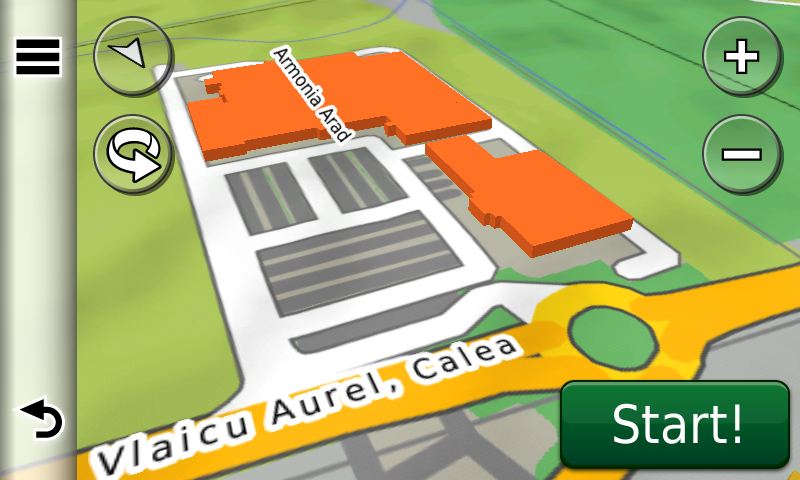
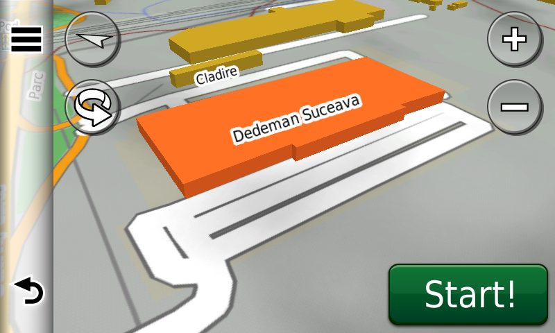
Detailed acces to the retail stores: Carrefour and Dedeman Calea Şagului from Timişoara, Lidl, Kaufland and Atrium from Calea Aurel Vlaicu from Arad, Piatra-Neamţ Shopping City, Lidl Bd. Decebal, Galleria Mall and Lidl Bd. Gen. Nicolae Dăscălescu from Piatra-Neamţ, Selgros Alba Iulia, Lidl Buhuşi, Lidl, Penny Market and Dedeman Bascov and Lidl Prundu from Piteşti, Lidl Frunzişului and Kaufland Fabricii de Chibrituri from Cluj-Napoca, Kaufland Barajului from Râmnicu Vâlcea, Kaufland Codlea, Kaufland Călăraşi, Dedeman and Kaufland 2 Satu Mare, Lidl Bacău, Penny Market Sovata, Kaufland Vatra Dornei, Kaufland and Dedeman Suceava, Dedeman Târgu Mureş, la Lidl and Kaufland Livezeni Târgu Mureş, Kaufland and Lidl Lugoj, Armonia, Brico-Depot, Dedeman and Expo Arad, cele două Lidl from Bârlad, Lidl Râmnicu Vâlcea, Kaufland Avram Iancu from Braşov, Platinia Cluj-Napoca, Penny Market Şimleu Silvaniei, Penny Market Aleşd, Dedeman, Ambient and Gold Plaza from Baia Mare, Carrefour and Dedeman Colentina, Dedeman Pallady, Lidl Pallady, Lidl Bucureştii Noi, Mega Image Pallady and Kaufland Bucureştii Noi, Mega Mall Pantelimon, Kaufland Pantelimon and Park Lake Titan from Bucureşti. New oneway streets and speed restrictions have been added together with 38 (thirtyeight) new roundabouts.
We also continued mapping the aristocratic mansions representing historical monuments from Transylvania, as well as orthodox monasteries from all over the country. We also mapped the historical crosses from Şcheii Braşovului, the Rudăria watermills from Eftimie Murgu and the historical monuments from Reghin.
The 2016 TUA limits (Territorial Administrative Units: commune, county and state boundaries), the alleys from the new Ploieşti Vest municipal park, the pedestrian zones and alleys from Cernavoda and Sebiş.
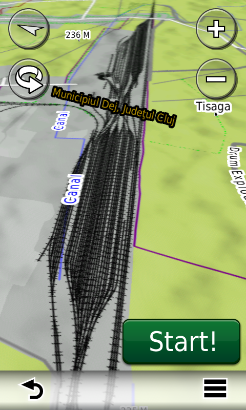
The railways junctions from Bistriţa, Cristeşti (Holboca), Ineu, Sântana, Vatra Dornei, Comăneşti, Vereşti, Augustin, Bârlad, Mihăileni, Izvoru Mureşului, Midia, Preajba railway station from Târgu Jiu and Dej have also been introduced. The Traian Dârjan airfield from Dezmir and the new configuration of the Baia Mare runway have been included.
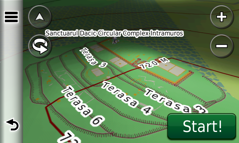
History aficionados will discover in this edition in premiere the detailed elements of the previously unknown neolithic fortification from Hoiseşti – Dealul Plopişte, of the Dacian fortifications from Racu-Dealu Bogat, Covasna-Cetatea Zânelor, Cernat-Vârful Ascuţit, Biborţeni-Taborc, Bixad-Cetatea Vapa, Racoş-Piatra Detunată, Ormeniş-Tipia Ormenişului, Pinticu Tecii-Cetăţuia, of the Dacian fortified settlement from Liteni-Piatra Mare, of the Dacian/medieval fortification from Sândominic, of the Roman? Castrum? from Baraolt – Cetatea Bac (previously unknown!), of a possible Roman Burgus from Luminiţa-Cimitir (previously unknown!), of the Roman Tower from Negrileşti-Dealul Sflederului, of the Roman Burgus from Negrileşti-Cetatea lui Negru-Vodă, of the Roman towers from Negrileşti-Cornul Malului, Ciceu-Poieni-Vârful Osoiului, Purcărete-Faţa Carpenului, Ciceu-Poieni-Strunga Găvojdenilor, Dobricel-Vârful Lazului, Dobricel-Locul Fătului, Sita-Casa Urieşilor, Perişor-Corobană, Perişor-Vârful Zgăului, Perişor-Vârful Colnicului and Ciceu-Poieni-Podul Milcoiei, of the Roman road, Burgus and tower from Băile Homorod-Foldvar and of the Roman? Burgus? from Satu Mare-Cekend, of the Roman towers from Vălişoara-Valea Rea, Rogna-La Bontauă, Cormeniş-Dealul Hoancelor, Cormeniş-Picioarele Andreichii and de la Negreni-Podireu as well as the Roman auxiliary Castrum from Viile-Cimitir. The positions of the Dacian fortification from Miercurea Ciuc-Jigodin IV, Dacian? Stronghold from Coşeiu-Poganyvar, of the Dacian temple from Covasna-Cetatea Zânelor, of the Roman altar from Adamclisi, of the Roman? auxiliary Castrum from Grojdibodu, of the Turkish medieval ditch fortification „from Igriş” (sic!) from Ezeriş and of the medieval fortification Arcis Rudera from Felnac, have also been mapped as points of interest. The detailed elements of the medieval earth fortifications Tordavar from Moldoveneşti – Cetatea Vămii de Sare and from Lunca de Sus-Alte Schanze, of the pre-modern Austrian forts from Brădet, the modern trenches from Vârfu Ursoiu, the previously unknown artillery fort from Cojocna-Straja Mică, the Hungarian antitank ditch belonging to the Arpad Fortified Line from the Second World War from Izvoru Mureşului, tens of monuments from the first and second world wars and military cemeteries, as well as the interbelic names of the oil refineries from Ploieşti have also been added in this map edition.
Featuring an original concept, with updates three times a year, the result of more than 13 years of continuous development of the experts and contributors of the Digital Romania Project team (www.romaniadigitala.ro), the Digital Atlas of Romania is the choice of professionals in all fields and the preferred navigation tool for all nature goers.
This edition has 1.01 GB in size and runs exclusively on Garmin navigation equipment, an updated list of compatibility being available at the below link:
http://www.rqa.ro/produs.php?id=442&subcat_id=39&cat_id=19
Warning!
The use of RO.A.D.2017.13 map can create addiction to quality, value, functionality and beauty!