RO.A.D.2019.10 Launch
RQA, a Garmin technology dealer in Romania, has the pleasure to announce the availability of the new edition of the Digital Atlas of Romania v11.10, RO.A.D.2019.10.
Continuing in the well known tradition for the Romanian Garmin customers, the Digital Atlas of Romania holds on to the number one place in the GPS road navigation map charts by bringing an extra 6,733.83 km of roads up to a grand total of 443,761.40 km, having significant increased coverage added in the counties of Bacău, Constanţa, Suceava, Dâmboviţa, Argeş and Bihor and the number of POIs raises in this edition to a staggering 890.983 points divided into 522 categories.
RO.A.D.2019.10 is the only GPS navigation map in the world that combines topographic details with a routable road network – including dirt roads and trails – with postal addresses of unequaled precision, towns with extruded 3D blocks of flats and detailed 3D textured models for both old patrimony buildings and new skyscrapers, true landmarks of today’s urban space. Map updates are constant and consistent from one edition to another and are documented in the Map Diaries, where all the contributions and their respective authors are mentioned together with the names of the cities and the map tiles that have changed.
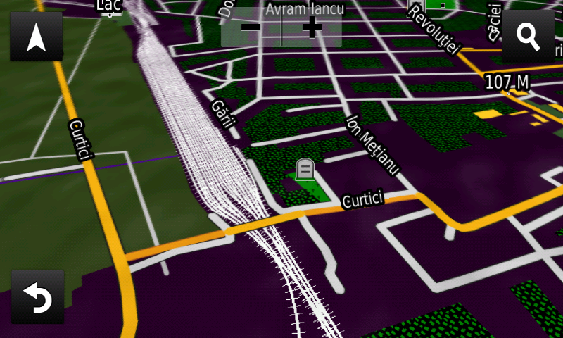
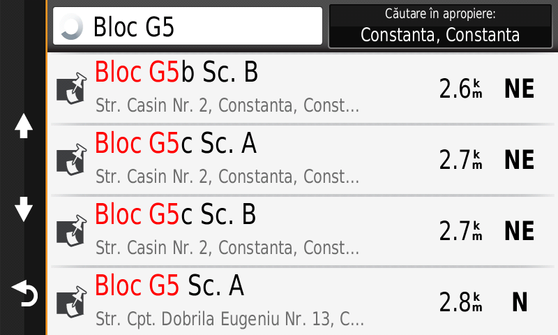
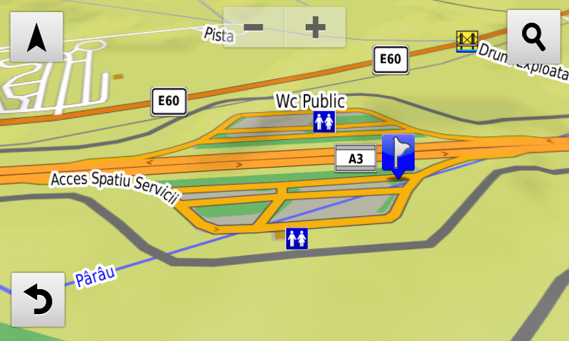
Compared with common maps on the market, the Digital Atlas of Romania has an unequaled level of detail, coverage and actuality, featuring, among others, the suspended roundabout and the Maintenance and Coordination center from Poiana node on A4 motorway, the passage over the railway from Curtici and the new service exits from A3 motorway from Sânpaul. Address-ability at block stair level has been introduced in Constanţa at over 1,700 blocks of flats.
In this edition we have postal addresses added in the following towns: DĂRMĂNEŞTI, DĂRMĂNEASCA, LAPOŞ, PODEI, SĂLĂTRUC, COMĂNEŞTI, VERMEŞTI, MOINEŞTI, CERNAVODĂ (south), VALEA DACILOR, SIMINOC, MURFATLAR, POIANA, REMUS OPREANU, MEDGIDIA, HOLDA, COTÂRGAŞI, PIETROASA, FRASIN (BROŞTENI), HĂLEASA, LUNGENI, BROŞTENI, NEAGRA, HOLDIŢA, IESLE, DÂRMOXA, PUCIOASA, PUCIOASA-SAT, GLODENI (PUCIOASA), MALURILE, MICULEŞTI, DIACONEŞTI, BELA, BEREVOEŞTI, FIENI, COSTEŞTI, CÂMPULUNG, VALEA RUMÂNEŞTILOR, BEIUŞ (north) and DELANI.
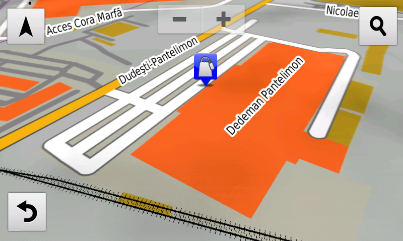
Detailed access to the retail stores: Lidl Aurel Vlaicu from Arad, Dedeman Pantelimon and Kaufland Şos. Alexandriei from Bucureşti, Penny Bolintin-Vale and La Strada Militari from Chiajna, Mega Image and Carrefour from Berceni has been introduced. New one way streets and speed restrictions have been added together with 17 (seventeen) new roundabouts.
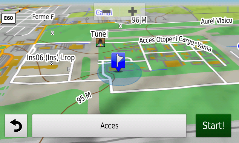
The detailed access to the Renault Bucharest Connected and the logistical centers from the Otopeni Airport have been introduced.
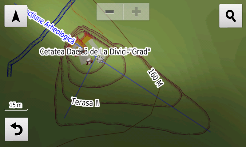
History aficionados will discover in this edition in premiere the detailed elements (ditch, walls, towers) of the Dacian fortress from Divici-Grad, the probable location of the roman castrum Mudava?!? from Moldova Veche-Selişte, the rampart and point of the roman castrum? from Iam as well as a previously unknown fortification (point, rampart, ditch) from Divici, probably a roman castrum. The former state boundary between Romania and the Habsburg Empire and the Romanian and Austrian guard posts along it have been mapped in the L35-017 map tile and other various heroes commemorative monuments from the two world wars.
Featuring an original concept, with updates three times a year, the result of more than 15 years of continuous development of the experts and contributors of the Digital Romania Project team, the Digital Atlas of Romania is the choice of professionals in all fields and the preferred navigation tool for all nature goers.
This edition has 1.02 GB in size and runs exclusively on Garmin navigation equipment, an updated list of compatibility being available at the below link:
http://www.rqa.ro/produs.php?id=442&subcat_id=39&cat_id=19
Warning!
The use of RO.A.D.2019.10 map can create addiction to quality, value, functionality and beauty!
-

- ADRESABILITATE LA NIVEL DE SCARĂ DE BLOC ÎN CONSTANŢA ÎN ROAD2019.10 PE NUVICAM
-

- CENTRELE LOGISTICE DE LA AEROPORTUL OTOPENI ÎN ROAD2019.10 PE NUVICAM
-
- CETATEA DACICĂ DE LA DIVICI-GRAD ÎN ROAD2019.10 PE NUVICAM
-
- DEDEMAN PANTELIMON ÎN ROAD2019.10 PE NUVICAM
-

- SENSUL GIRATORIU SUSPENDAT DE LA NODUL RUTIER POIANA AUTOSTRADA A4 ÎN ROAD2019.10 PE NUVICAM

-
- SPAŢIUL DE SERVICII AUTOSTRADA A3 DE LA SÂNPAUL
-
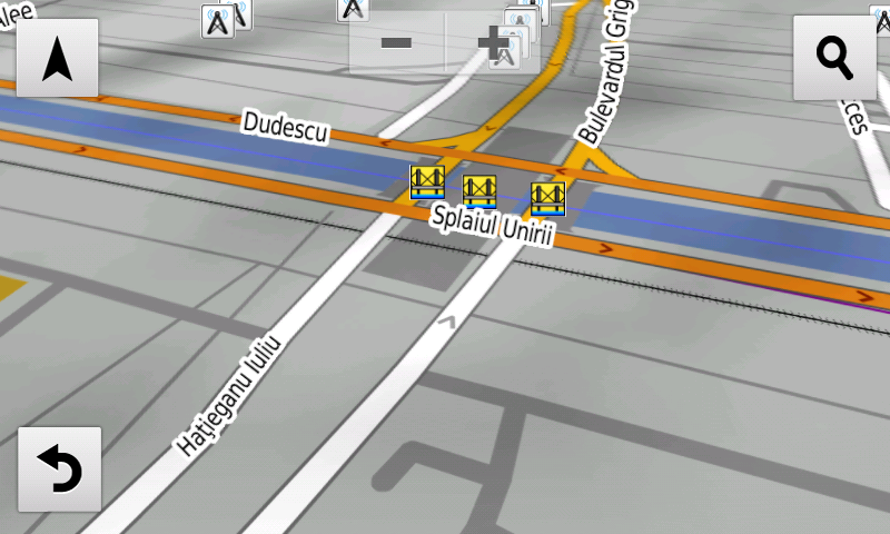
- LEGĂTURA IULIU HAŢIEGANU DIN BUCUREŞTI ÎN ROAD2019.10 PE NUVICAM
-
- PASAJUL PESTE C.F. DE LA CURTICI ÎN ROAD2019.10 PE NUVICAM