RQA, a Garmin equipment importer in Romania, has the pleasure to announce the availability of the new edition of the Digital Atlas of Romania v10.09, RO.A.D.2018.09.
Continuing in the well known tradition for the Romanian Garmin customers, the Digital Atlas of Romania holds on to the number one place in the GPS road navigation map charts by bringing an extra 5,279.00 km of roads up to a grand total of 417,664.25 km, having significant increased coverage added in the counties of Bihor, Maramureş, Harghita, Suceava, Ilfov and Alba and the number of POIs raises in this edition to a staggering 865,376 points divided into 518 categories.
RO.A.D.2018.09 is the only GPS navigation map in the world that combines topographic details with a routable road network – including dirt roads and trails – with postal addresses of unequaled precision, towns with extruded 3D blocks of flats and detailed 3D textured models for both old patrimony buildings and new skyscrapers, true landmarks of today’s urban space. Map updates are constant and consistent from one edition to another and are documented in the Map Diaries, where all the contributions and their respective authors are mentioned together with the names of the cities and the map tiles that have changed.
Compared with common maps on the market, the Digital Atlas of Romania has an unequaled level of detail and actuality, featuring, among others, the residential areas at block name-postal address level from Năvodari, the center of Popeşti-Leordeni town as well as from the Timiş Triaj and Avantgarde 1, 2 and 3 from Braşov.
The Bega vaporetto stations, Aqua Park from Cornişa and Terra Park from Bucureşti have been mapped, together with access to them.
In this edition we have postal addresses added in the following towns: ORADEA, Cheresig, Biharia, Sândominic, LUNCA ILVEI (East), ARGESTRU, ROŞU, VATRA DORNEI, ALBA IULIA, PÂCLIŞA, MICEŞTI, BĂRĂBANŢ, CIUMBRUD, SÂNCRAI, TEIUŞ, CĂPUD, PEŢELCA, AIUDUL DE SUS, AIUD, Gârbova de Jos, ŢIFRA, GÂRBOVA DE SUS, PETRISAT, BLAJ, VEZA, IZVOARELE, ŢIUR, OARDA, TĂUŢII-MĂGHERĂUŞ (North), BĂIŢA, NISTRU, SĂBIŞA, SEINI, VIILE APEI, NEGREŞTI-OAŞ, ADRIAN, LIVADA MICĂ, LIVADA, DUMBRAVA, Popeşti-Leordeni and Bragadiru.
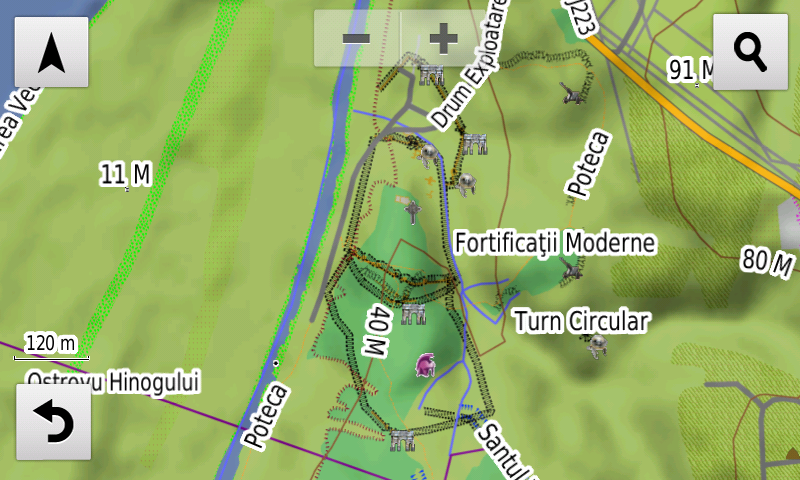
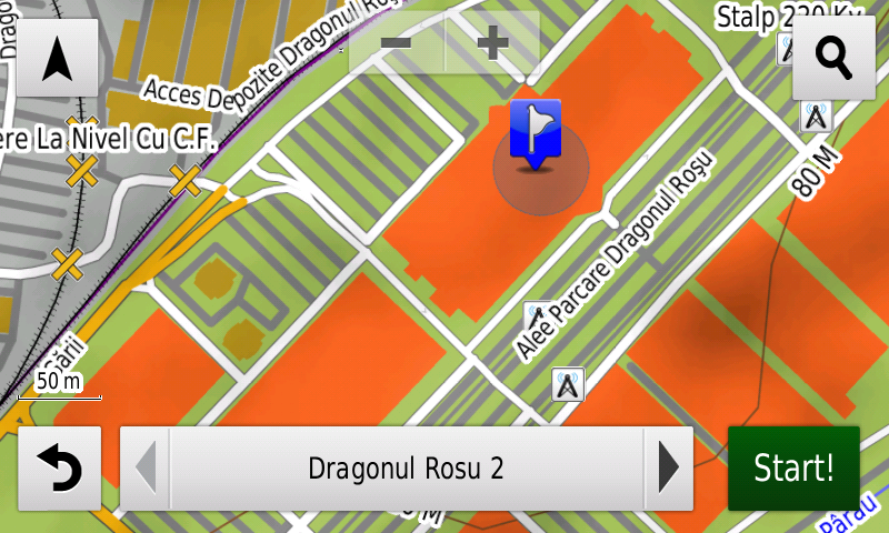
Detailed acces to the retail stores: Cora and Lidl Brătianu, Kaufland Vivo from Constanţa, Kaufland Olteniţei, Lidl Drumul Binelui, Lidl Sergent Nuţu Vasile, Mega Image Vatra Luminoasă, Dragonul Roşu 1, Mega Image Pucheni, Lidl Teiuş from Bucureşti, Penny Market Drumul Fermei from Popeşti-Leordeni, Penny Market from Bragadiru, Expomarket Doraly 2 from Afumaţi and the commercial complex Dragonul Roşu 2-9 from Dobroeşti. New oneway streets and speed restrictions have been added together with 18 (eighteen) new roundabouts.
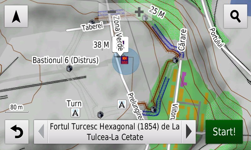
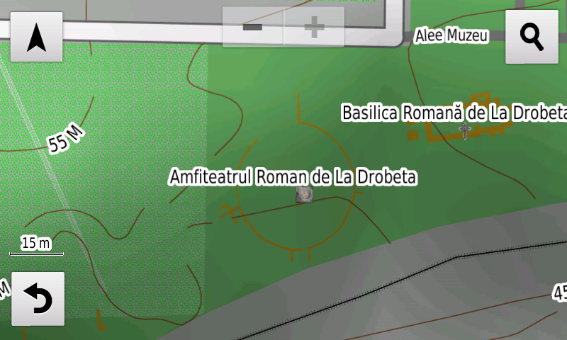
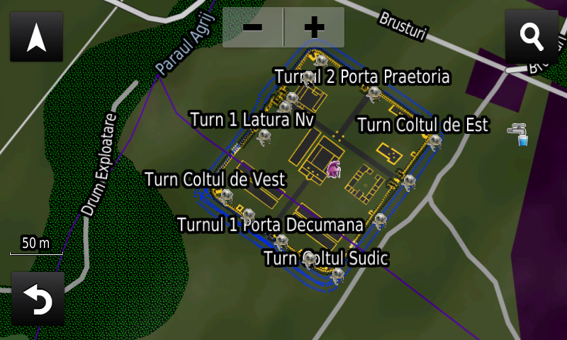
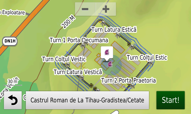
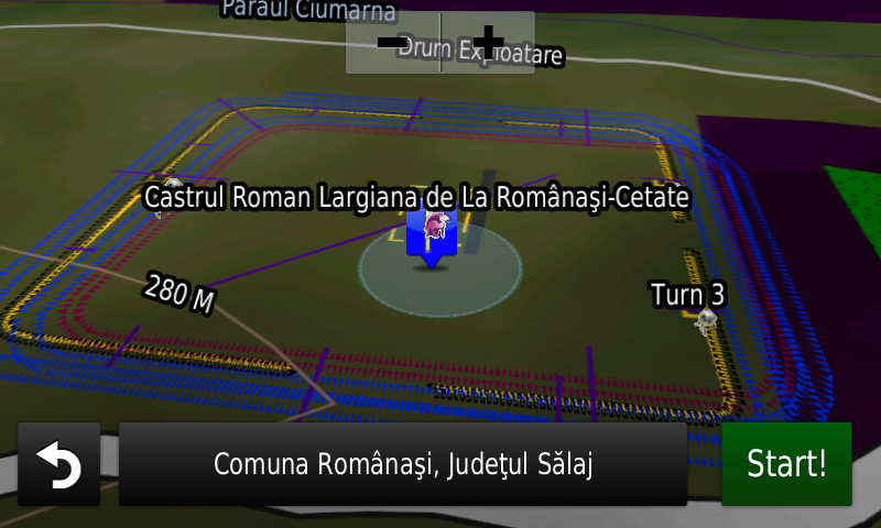
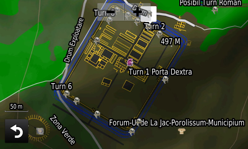
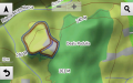
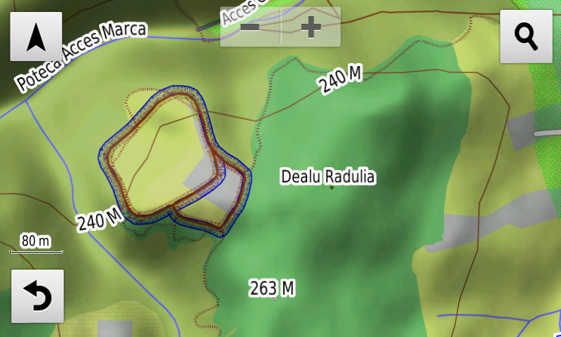
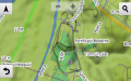
History aficionados will discover in this edition in premiere the detailed elements (ditches) of the Tell type fortified settlement from Uivar, the detailed elements (rampart, ditch) of the Gava Culture settlement from Căuaş-Sigheţiu, the detailed elements (ramparts, ditches) of the Iron Age fortified settlement from Marca-Iertaşul Petacilor, the detailed elements (rampart, ditch) of the late Iron Age fortified settlement from Tulcea-La Cetate/Troianul from Tulcea, the detailed elements (rampart, ditch) of the Iron Age fortified settlement from Jac-Dealul Cămnini, of the La Tene stronghold from Moigrad-Măgură (ditches), two square fortifications of undetermined age from Zoreni, the detailed polygons of the Roman amphitheater from Drobeta, of the Roman Horreum from Şibot-Obreje, the detailed elements (walls, buildings, towers, ditches) of the Roman Castrum Certiae/Cersiae from Brusturi, the detailed elements (walls, buildings, towers, ditches) of the Roman Castrum from Tihău-Grădişte, the detailed elements (walls, buildings, towers, ditches) of the Roman Castrum Largiana from Românaşi-Cetate, phase 1 (wood) and 2 (stone), the detailed elements (rampart, ditch) of the Roman Burgus from Zalău-Fântâna Suşigului, ), the detailed elements (buildings, ballistarium, second ditch) of the Roman castrum Porolissum-Pomet from Moigrad-Porolissum, the detailed elements (ditch) of the Roman? castrum from Lespezi, the detailed elements (rampart) of the Roman? castrum from Sarighiol din Deal-Dealul Câmpul Verde, a possible Roman castrum at Izvoru Crişului-Dealu Borzica, the detailed elements (wall polygons) of the thermae of the Angustia Roman castrum from Breţcu, of the Roman tower (rampart) from Jac-Dealul Cămnini, the detailed elements (buildings E1-4 polygons, delimitation ditch) of the Villa Rustica from Tărtăria II, the detailed elements (polygons and lines walls and incints, tower points) of the Roman-Byzantine fortress Carsium from Hârşova, the detailed elements (polygons and lines walls and precincts, gates, the two Basilica and the late precinct, tower points) of the Roman-Byzantine fortress Axiopolis from Cernavoda, the Roman? fortlet? from Şendreni together with a previously unknown similar fortification in its vicinity. Parts of the Moigrad-Porollissum Limes valla have been reconfigured, revisions were made to the aspect (ramparts, ditches) of the Roman-Byzantine stone castra XIII from Poarta Albă, (XXA), VII, VIII from Murfatlar, of the castellum o and the Roman-Byzantine earthen castra 20 from Poarta Albă, 13, 14 and 15 from Murfatlar, of the stone castella k, l, m and the one between the 14 and 13 castra from Murfatlar, the XX, XIX, XXII stone castra from Peştera, the earthen 30, 29 castra from Peştera, the stone castella z, y and x from Peştera, of the roman earthen 4, 5 and 6 castra and of the stone castella b, c, d, e and f from Valu lui Traian. The detailed elements (ramparts, ditches) of the Roman-Byzantine earthen castrum 3,2 and 2′ and stone castrum II from Constanţa were introduced together with additions to the trajectory of the stone vallum, and large and small earthen valla from Constanţa. From the Medieval period the detailed elements (rampart, ditch) of the ottoman Tabyas Arap Tabia and Tabia 1? (rampart?!?), the eastern half of the Small Tabya (rampart, ditch) from Babadag, the detailed elements (rampart, ditch) of the Turkish Palanka from Vârfurile, the ditches of the ottoman Tabyas from Hârşova, a possible fortification at Babadag-Cimitirul Evreiesc, the detailed elements of the hexagonal 1854 ottoman fort (rampart, ditch, bastions) and of the Tabya number 2 (rampart, ditch) from Tulcea-Dealul Tulcea Veche, the supposed contour of the rampart and ditches of the early medieval stronghold from Ortelec/Zalău-Cetate, comemorative World War I monuments (the WWI romanian heroes cemetery from Porumbacu de Sus, the WWI romanian soldiers osuary from Diham and the current position of the Molomoţ cross, etc. ).
Featuring an original concept, with updates three times a year, the result of over 14 years of continuous development of the experts and contributors of the Digital Romania Project team, the Digital Atlas of Romania is the choice of professionals in all fields and the preferred navigation tool for all nature goers.
This edition has 1.02 GB in size and runs exclusively on Garmin navigation equipment, an updated list of compatibility being available at the below link:
http://www.rqa.ro/produs.php?id=442&subcat_id=39&cat_id=19
Warning!
The use of RO.A.D.2018.09 map can create addiction to quality, value, functionality and beauty!
-
- Amfiteatrul Roman de la Drobeta în RO.A.D.2018.09 pe Nuvicam
-
- Blocuri Avantgarde Braşov în RO.A.D.2018.09 pe Nuvicam
-

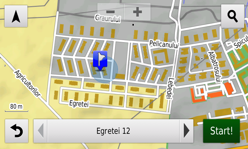
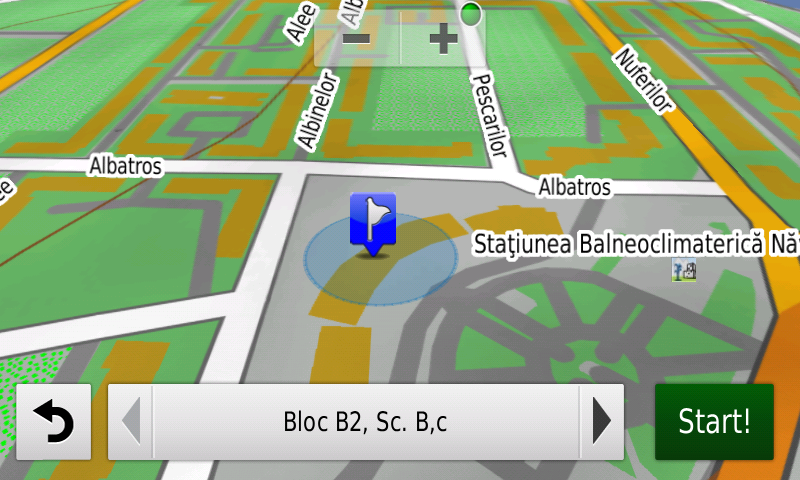
- Blocuri Năvodari în RO.A.D.2018.09 pe Nuvicam
-
- Castrul Roman Certiae de la Brusturi în RO.A.D.2018.09 pe Nuvicam
-
- Castrul Roman de la Tihău-Grădişte în RO.A.D.2018.09 pe Nuvicam.
-
- Castrul Roman Largiana de la Românaşi în RO.A.D.2018.09 pe Nuvicam
-
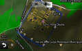
- Castrul Roman Porolissum-Pomet în RO.A.D.2018.09 pe Nuvicam
-
- Cetatea de epoca fierului de la Marca-Iertaşul Petacilor în RO.A.D.2018.09 pe Nuvicam
-
- Cetatea Romano-Bizantină Axiopolis de la Cernavodă în RO.A.D.2018.09 pe Nuvicam
-

- Dragonul Roşu în RO.A.D.2018.09 pe Nuvicam
-

- ExpoMarket Doraly în RO.A.D.2018.09 pe Nuvicam
-
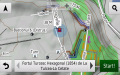
- Fortul otoman hexagonal de la 1854 de la Tulcea-Dealul Cetăţii în RO.A.D.2018.09 pe Nuvicam